
The Barnegat Bay estuary itself is very shallow, with a relatively small amount of freshwater input and a limited connection with the ocean. These factors cause a slow flushing time and makes the estuary highly vulnerable to degradation from the watershed (e.g., conversion of natural lands to urban areas).
Population Growth and Land Use Trends
The Barnegat Bay watershed lies almost entirely within Ocean County. An exception is the portion of southern Monmouth County within the Metedeconk River subwatershed, which discharges to the Barnegat Bay.
According to the Comprehensive Conservation and Management Plan (CCMP), since 1950, Ocean County’s population has increased by more than 775%. The watershed area’s population is now over 565,000, a figure that more than doubles during the summer season. Municipalities on the barrier islands may experience a 10-fold increase in population during the summer.
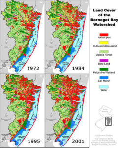
Residential development is the primary land use in the watershed (CCMP). Recent mapping efforts by the Rutgers University Grant F. Walton Center for Remote Sensing & Spatial Analysis (with funding from the Barnegat Bay Partnership) reveals that urban land use in the Barnegat Bay watershed increased from approximately 25% in 1995 to 30% in 2006. Including all altered land uses (i.e., agricultural and barren lands) puts the percentage of altered land in the watershed at over 33% in 2006. The conversion of forested upland and wetland habitats to urban land cover (i.e., impervious surfaces) increases polluted stormwater runoff and contributes to degraded water quality in the estuary.
According to the same study, approximately 1,920 acres of riparian habitat were converted to urban areas between 1995 and 2006 (to access the full report, entitled, “Assessment of Land Use Change and Riparian Zone Status in the Barnegat Bay and Little Egg Harbor Watershed: 1995-2002-2006” visit the Studies and Reports page of our website).
More than 70% of the Barnegat Bay estuarine shoreline buffer zone is developed or altered, leaving only 29% in natural land covers. Approximately 45% of the estuarine shoreline is bulkheaded (CCMP).
According to the 2005 State of the Bay Report, as of March 2004, there were approximately 122,500 acres of publicly-owned land in the Barnegat Bay watershed (approximately 34% of the watershed) and thanks to key BBP partners, that figure has increased each year since.
Can we develop the land with less impact on Barnegat Bay?

All too often, traditional and prevailing development practices that clear natural habitats and compact soils in preparation for construction have detrimental impacts on water quality and water supply. Low Impact Development (LID) presents an alternative to conventional development and is gaining in popularity nationwide. LID is an integrated site design approach for addressing hydrologic and environmental impacts often associated with conventional land development. Developers and builders can save money and reduce environmental impacts in a practical manner utilizing LID techniques and practices, which include minimizing grading during site preparation, impervious area disconnections, preservation of landscaping and topography, and increasing opportunities to mimic pre-existing hydrology. For more information on LID practices for the Barnegat Bay watershed, see A Guide to Low-Impact Development in the Barnegat Bay Watershed by the Pinelands Preservation Alliance.
Related Links
Barnegat Bay Resources at the Grant F. Walton Center for Remote Sensing and Spatial Analysis
Coastal Land Use Management Resources at the Jacques Cousteau National Estuarine Research Reserve
New Jersey Department of Environmental Protection Division of Land Use Regulation
Ocean County Department of Planning
Ocean County Soil Conservation District
USEPA Low Impact Development resources
